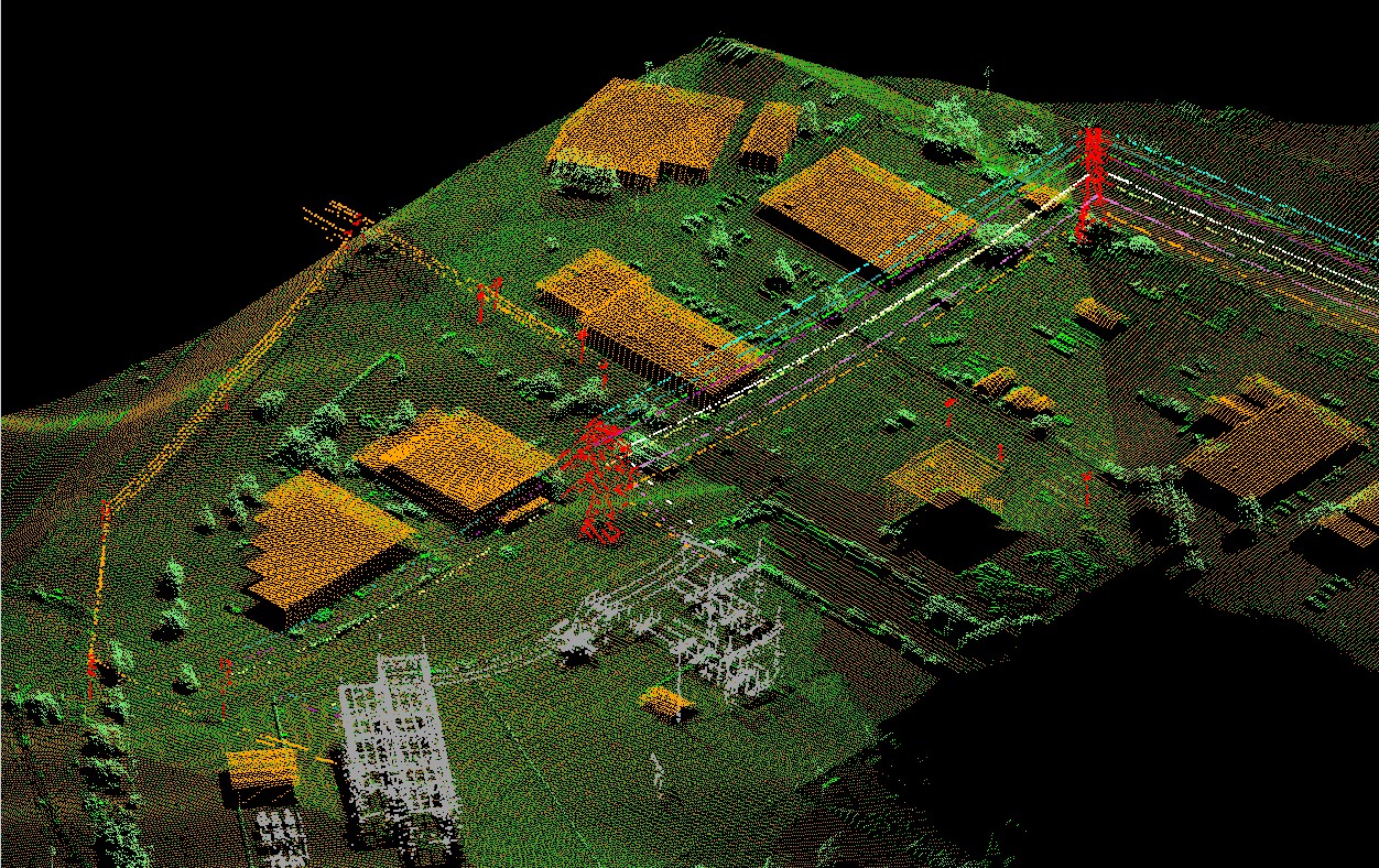
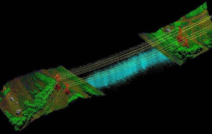
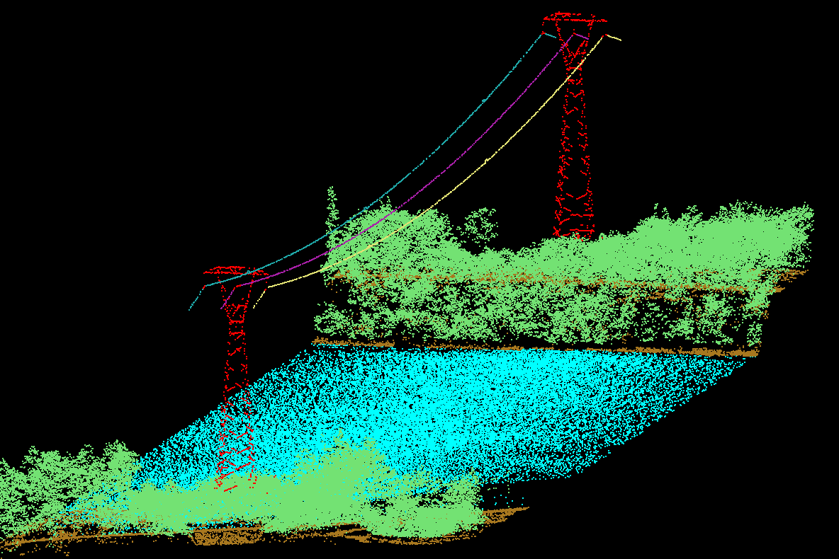
Aerial LiDAR provides a complete 3D as-built of the entire transmission ROW
North American Electric Reliability Corporation (NERC) Reliability Standard FAC-003-3 for transmission vegetation management goes into effect In July 2014. It stipulates that lines need to be routinely inspected once a year …it does not, however, recommend the best method of inspection. Increasingly, utilities find that aerial manual inspection and foot patrols are inadequate when it comes to ensuring against vegetation related threats. Many utilities turn to aerial LiDAR and imagery surveys to broaden their vegetation management program and to ensure compliance with Standard FAC-003.
Aerial LiDAR/Imaging surveys are able to rapidly identify critical clearances, danger and hazard vegetation and abnormal line states. The acquired LiDAR data can be processed to identify probable clearance violations along the right-of-way. Clearance violations and other problems are then provided to the utility in a summary report containing images and data in a format that allows for immediate action in the case of vegetation or imminent reliability issues.
Also, for the first time, FAC-003-3 requires transmission owners to annually inspect all transmission lines subject to the standard and to complete 100 percent of their annual vegetation work plan. The Reliability Standard also incorporates the Minimum Vegetation Clearance Distance (MVCD) into the text of the standard, and does not rely on clearance distances from an outside reference.
LiDAR is able to identify vegetation clearance concerns that are not found in routine patrols.
LiDAR is able to identify vegetation clearance concerns that are not found in routine patrols flown with human observers. The accuracy of the data enables utilities to provide precise locations of vegetation requiring maintenance. The LiDAR survey looks at the entire ROW, including trees located off the ROW which may fall into the line. When utilities do aerial or foot patrols, they routinely focus only on the power lines and adjacent vegetation, while the LiDAR survey provides a complete digital 3-D survey of everything on and along the ROW.
LiDAR Services International’s, Calgary, Alberta, Canada airborne LiDAR/Imaging systems have been providing many different mapping and data collection services for the electrical utility industry, from preliminary route mapping, environmental evaluation, and vegetation management to as-built transmission line facilities since 2002. The mapping for each of these project styles has unique requirements, analysis and deliverables. They are addressed by LIDAR Services in-house expertise to develop proprietary solutions to provide one stop project services from data collection and analysis through to transmission line re-rating, thermal rating and vegetation analysis.
Typically, a routine aerial or foot patrol of transmission lines and vegetation provides a “snapshot in time” of what conditions are on any given
LiDAR provides the inspector the ability to review lines and corridor conditions with a high degree of accuracy on their desktop.
day. LiDAR re-flights have the advantage of not only providing data on current conditions, but change detection algorithms in conjunction with the LiDAR can be used to perform audits of completed vegetation work accomplished since the last LiDAR flight. At the end of the day, LiDAR gives utilities a better sense of being in compliance than they were able to achieve with human observation alone.
LiDAR provides the inspector the ability to review lines and corridor conditions with a high degree of accuracy on their desktop, at their own pace, without the distractions of flight dynamics. These surveys have demonstrated the capability to produce Clearance Reports quickly, allowing utilities to respond immediately, or in an appropriate manner, to any imminent threats to the reliability of the line, record the incident and provide evidence and contextual information about the incident to their control center.
LiDAR Services’ MATRIX Aerial LiDAR/Imagery systems provide the most advanced method to create highly accurate, intelligent data for entire transmission ROW providing detailed power line and infrastructure information such as line sag, crossing violations, vegetation clearances, and encroachments. The systems are designed to meet the precision survey requirements of electrical utilities providing the capability to acquire high-resolution LiDAR data, Ortho-images and oblique images of every inch of a power-line corridor. It can also be redeployed for accurate, cost effective condition change management over time. LiDAR provides the complete answer …when properly specified, managed and provided by a competent contractor. In addition, geospatial and engineering databases can be created from LiDAR and imagery that benefit multiple groups within the utility, including engineering, construction, encroachments and line maintenance.
What utilities need to know…
 Utilities are engaged in an endless battle waged to control vegetation, with great potential consequence, to ensure reliability of the nation’s electric power grid. Now utility ROW managers, engineers, and foresters have available to them, literally, the culmination of man’s technological advances in situational awareness, intelligence and information technology, and the same LiDAR survey can benefit all groups associated with the effective management of electric transmission lines.
For the past few years, most utility LiDAR activity has been focused on satisfying FAC- 008 regulating facility ratings and not FAC- 003 which deals with vegetation management. LiDAR surveys for facility rating are much more labor intensive and require much higher LiDAR point densities and collection of other data driving up the level of complexity and costs. However, once the LiDAR survey for facility thermal rating has been done, creating an accurate baseline, follow-on surveys for vegetation management can be much easier and economical.
Operational Needs
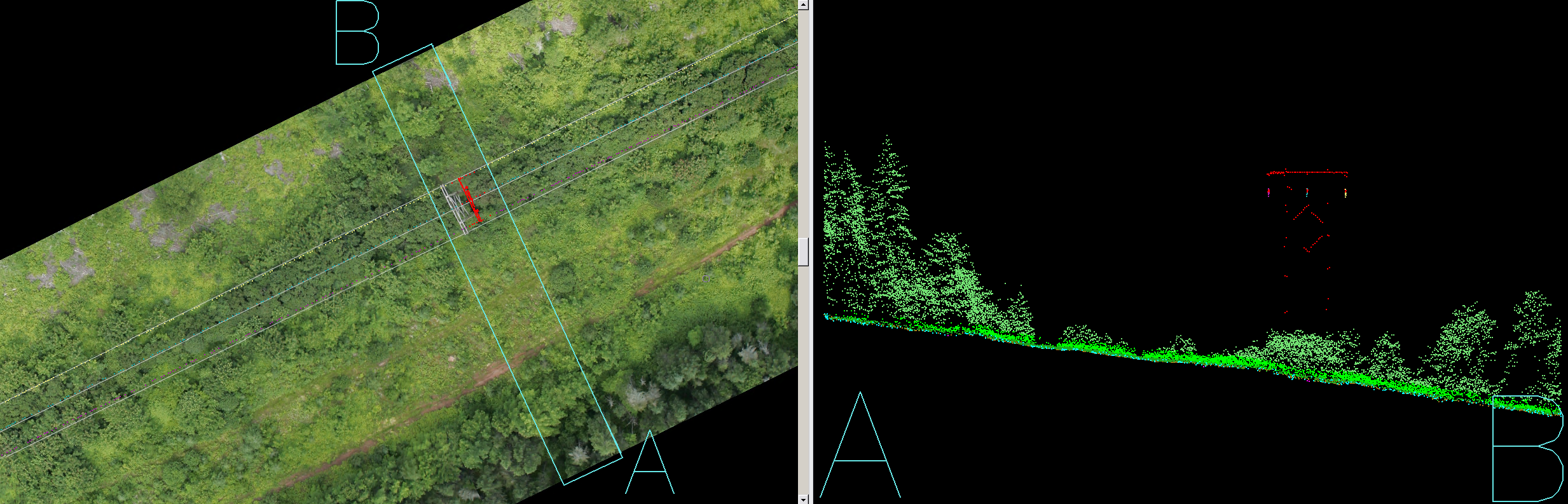
Increasingly, facility owners and utility ROW managers recognize the need for the right tools to manage wire condition risks, field and 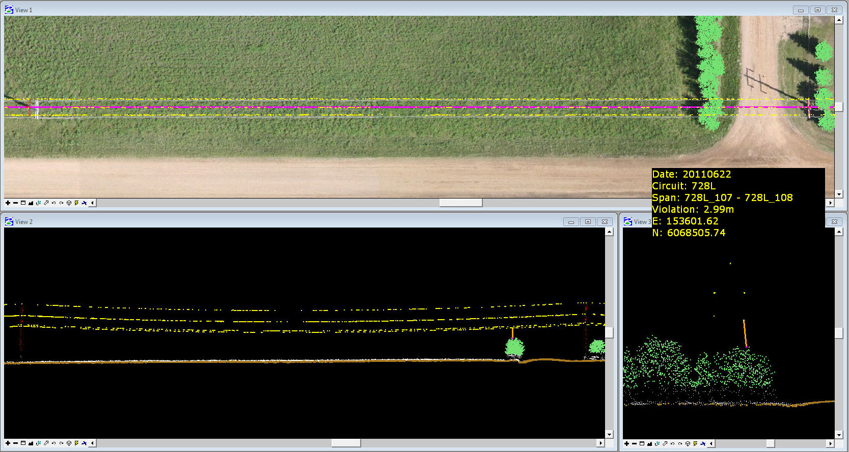 operation issues, auditing, and remediation of emergent issues. By making LiDAR data, ortho photos and other information accessible to all interested personnel in a manner that is understandable to all parties is becoming an increasing priority. For electric transmission applications, it is beneficial to display LiDAR data in 3D, by height, intensity, and classifications; Analyze the data by creating profiles; Classify profiles and get information from each point, utility personnel can detect danger areas, measure pole distances, height of wires and monitor valuable infrastructure.
Utilities face tremendous operational challenges every day in managing transmission lines and ROW’s. They need to decide what equipment or machinery to use when accessing a given line or span that may be restricted by virtue of terrain, land use, steepness, remote access, habitat etc. Having LiDAR, ortho photos and other geographic information accessible to all team members make these day to day operational challenges easier and with less risk when addressed online in the office saving expensive, time-consuming trips to the field. LiDAR Services provides classification of data, vectorization of transmission networks, and risk evaluation of vegetation encroachment into power lines. They classify the original LiDAR data and provide rapid, accurate classified data in specified themes, such as: Buildings, Wooden poles, Ground, Vegetation (high, medium, low), Infrastructure, electric towers, Power lines (2D, 3D), Roads and other encroachments.
Conclusion:
For last few years, considerable anxiety and uncertainty revolved around satisfying FAC- 008 regulating facilities’ ratings and not FAC- 003 which deals with vegetation management. The purpose of the NERC Reliability Standard FAC-003-3 is to improve the reliability of the electric transmission system by preventing vegetation related outages that could lead to cascading outages. Compliance with the standard is mandatory and enforceable and an outage can mean fines, mitigation costs and many hours lost by utility foresters in responding to requests by the Regional Entity concerning the outage. LiDAR and imagery data can provide Transmission Owners documentation that identifies areas not meeting the Transmission Owner’s standard for vegetation management and any mitigating measures the Transmission Owner needs to take to address these deficiencies. It allows them to review current conditions to effectively plan future vegetation management work and subsequent cyclical maintenance activities while minimizing the need for confirmatory ground survey activities.
LiDAR Services’ Vegetation and Asset Management ROW Surveys show where, when and how utility vegetation managers should apply their prescriptions and comply with vegetation regulatory issues. LiDAR provides utility vegetation and ROW managers the situational awareness, intelligence and information technology to ensure they are in compliance with Reliability Standards and avoid costly vegetation related outages.
For more information, in the U.S.A. visit www.lidarservices.com and in Canada visit www.lidarservices.ca or call 888-870-9972.
###